- 1. 10 Places Google Maps Hides
- 2. San Blas Archipelago
- 3. Area 51
- 4. Punggye-ri
- 5. Faroe Islands
- 6. Spratly Islands
- 7. Fort Isabel II
- 8. Jeanette Island
- 9. North Sentinel Island
- 10. 2215 Seymour Avenue
- 11. 21 Espíritu Santo
10 Places Google Maps Hides
The arrival of Google Maps in 2005 was a revolution, as it made having a world map just a click away on our phones and computers. Over the years, this application has been perfected, offering an increasing level of detail for any place in the world. Well, not for every place in the world. Intentionally, the most famous mapping app on the planet hides some locations for various reasons, and two of them are in Spain.
San Blas Archipelago

The San Blas Archipelago consists of 365 islands belonging to Panama and is a paradise, but these are hidden on Google Maps. Although the company does not provide explanations for this, it may be due to the presence of the Guna people. This indigenous population inhabits islands that are not open to tourism and have had very little social contact with the outside world. This concealment of the area could be an attempt to protect them from prying eyes or to reveal their exact location to the world.
Area 51

The infamous Area 51 has been featured in many sci-fi series and movies, but no one knows for sure what investigations are carried out behind its walls. It is a restricted area of over 1.2 million acres where more than 3,000 people work for the U.S. government. The purpose of the research and its objectives have never been entirely clear. The satellite images provided by Maps only show a small concrete building in the middle of the desert.
Punggye-ri
Punggye-ri is possibly the most unknown place in the world as it is a nuclear base in North Korea. Here, all kinds of weapons tests are carried out, especially with missiles. The area is so secret that the map shows it completely hidden as if it were the moor of a mountain, owing to the hermetic nature of the zone.
Faroe Islands

The Faroe Islands is another archipelago inhabited by about 50,000 people, yet it remains a mystery for those wanting to explore the world through maps. If we try to get close to its islands, they all end up being little more than a blurred spot. However, there does not seem to be an apparent reason for the application to hide this area which, let us remember, is inhabited.
Spratly Islands

We move to another more eastern archipelago, the Spratly Islands, which consists of nearly 100 reefs and islets. Although it is located in the South China Sea, its territory is divided among China, Taiwan, Vietnam, Malaysia, the Philippines, and Brunei, which has generated numerous disputes among the countries. It is likely that for this reason they have decided to remove it from the map. Although from a distance the silhouettes of the islands appear, they are covered by a black spot if we get closer.
Fort Isabel II
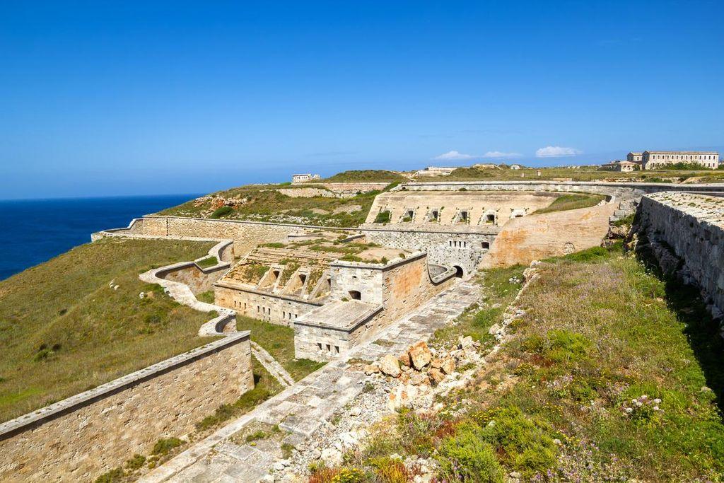
Fort Isabel II is located at the entrance of Mahón harbor in Menorca, and although there are images of the surroundings, its interior remains a mystery. This fortress protects the harbor entrance, but the entire area is completely pixelated. Both the fortress and the military area of Es Castell have been hidden from prying eyes to avoid problems.
Jeanette Island
Jeanette Island is the easternmost of the Long Islands in the Sea of Eastern Siberia. However, when searching for it on Google Maps, we find more water in its location. Where the island is supposed to be, as indicated by the application, we only see sea. Although this is the only island in the archipelago that appears erased, the reasons remain unknown.
North Sentinel Island
North Sentinel Island was in the news a few months ago after the death of a tourist who attempted to evangelize its population. This island is regarded as one of the most dangerous in the world due to having one of the few tribes that has never had contact with the outside world. For this reason, and to respect their privacy and customs, Google Maps has decided to hide it from the world.
2215 Seymour Avenue
2215 Seymour Avenue is neither cursed nor hiding anything, but it does have a sad story behind it. This house in Cleveland was the site where a maniac kidnapped three young girls and abused them for nearly a decade, which is why it earns the nickname 'house of horrors.' The application is quite sensitive with places where crimes have occurred, which is why the house appears pixelated in the middle of the street.
21 Espíritu Santo
For the same reason, the building at 21 Espíritu Santo Street in Madrid is hidden. In this block in the Malasaña neighborhood, the lifeless body of Enrique Urquijo, the singer of the group Los Secretos, appeared in November 1999. As a prominent figure of the time, Maps decided to pixelate the entire facade, leaving it hidden from prying eyes.
In conclusion, Google Maps has been designed to be a precise and detailed navigation tool for users worldwide. However, there are some places that the platform has intentionally chosen to hide, whether for security, privacy, or political reasons. These places can be extremely interesting and intriguing for those looking to explore and discover unique locations, but it is important to keep in mind that some of them may be dangerous or illegal to access.