5 Hiking Trails in Navacerrada
If you are used to walking through Madrid from one end to the other every time you visit, it's time to set aside the urban side and discover what its mountains have to offer, specifically, Navacerrada. This town is located in the Guadarrama Mountain National Park at an altitude of about 1,200 meters and has numerous and varied trails suitable for all levels and ages, accessible year-round. Additionally, due to its location, you can enjoy the vegetation along the trails, such as abundant forests of Scots pine, oaks, and, in the lower areas, holm oaks. At the summits, grasslands and alpine shrubs prevail. The wildlife in the area also adds to the charm of these trails. Mammals such as deer, wild boars, or roe deer are abundant, as well as a large number of species of water birds in the reservoirs and large raptors like the imperial eagle. Below, we suggest 5 trails you shouldn't miss:
Schmid Path
This is one of the most renowned trails not only in the Guadarrama Mountains but throughout the Community of Madrid (where this path begins and ends). It was traced at the beginning of the 20th century to link Navacerrada Pass with the municipality of Cercedilla and is named after the hiker Eduardo Schmid, who marked this route in 1926.
This mountain trail starts from Navacerrada Pass and runs along the north slope of the Siete Picos mountain range (at the boundary between the Community of Madrid and the province of Segovia), towards the Fuenfría Valley (Cercedilla, Madrid), finishing at the Peñalara Mountain Club Hostel. It is about a 7-kilometer route of low difficulty, designed to be completed one way. It is recommended to do it during summer, spring, and autumn, as it is usually covered in snow during winter.
The Ball of the World
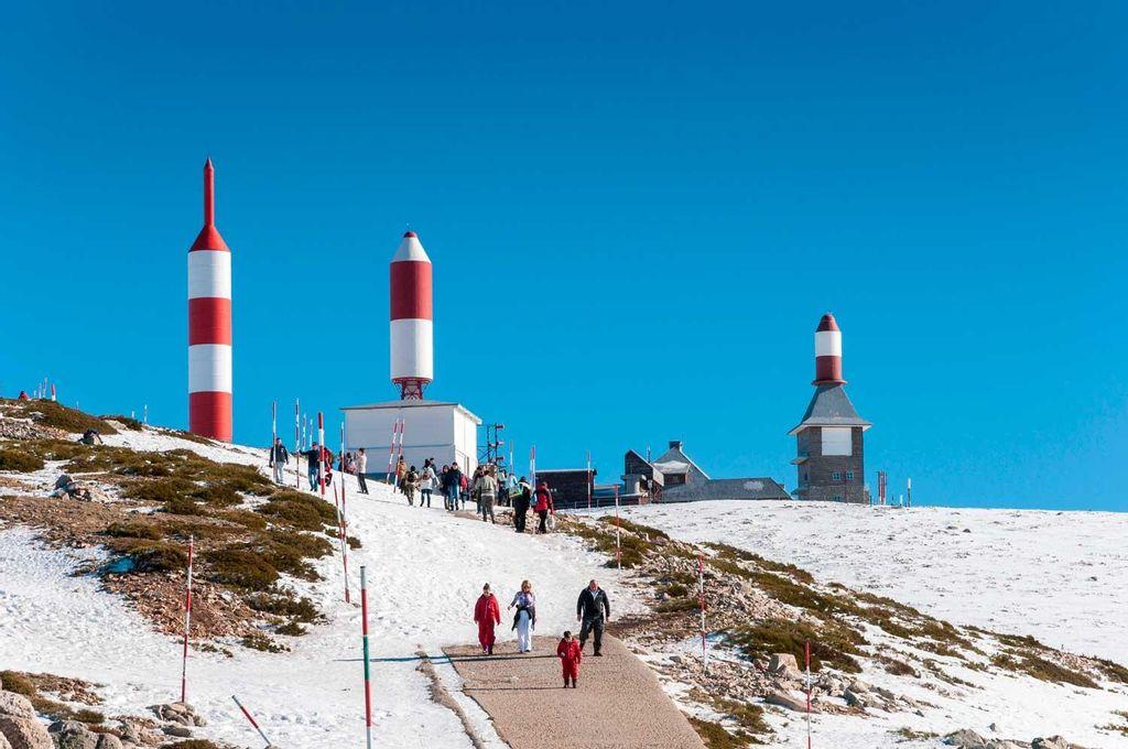
The Ball of the World is the popular name for the Alto de Guarramillas, which stands at 2,275 meters above sea level and belongs to the Cuerda Larga of the Guadarrama Mountain Range. This route can start from various places, although Navacerrada Pass is one of the most common. From here, the route is 8.4 kilometers long, including the descent. In terms of difficulty, it is moderate and varies depending on the season, as the presence of snow or wind can make conditions challenging.
A distinctive feature of this mountain is the television and radio antennas located on it. They are covered by a protector resembling a red and white rocket and often serve as a point of orientation for other routes.
La Maliciosa

It is the continuation of the route towards the Ball of the World, and at 2,227 meters above sea level, it is one of the most significant and striking mountains in the Guadarrama Mountain Range. It is located in the northwest part of the Community of Madrid, between La Pedriza and the Barranca Valley, and is also known as "The Nun" because of its monastic headdress appearance when covered in snow during winter. It was portrayed by Velázquez in the portrait "Prince Balthasar Carlos on Horseback."
The route, which starts at the Navacerrada Pass, consists of almost 14 kilometers when accounting for both ascent and descent. It is considered a trail of easy level despite the moderate climbs during the route. It is worth noting that when reaching the summit, there are often several imperial eagles soaring in the area.
Route of the 7 Peaks
This massif is geographically delimited by Navacerrada Pass to the east and Fuenfría Pass to the west, serving as the dividing line between Madrid and Segovia. The name comes from its unmistakable silhouette, as its ridge is marked by seven granite peaks numbered from west to east. The first of them, the lowest, is slightly separated from the others and is known as Pico de Majalasna. For its part, the seventh peak, the closest to Navacerrada Pass, is the highest and is known as Pico de Somontano.
It is a circular route that has its starting and ending point at Navacerrada Pass. Its difficulty level is medium and is 17 kilometers long. The idea is to conquer each of the peaks, as once the highest is climbed, there are no significant elevations to overcome, but there is also the option to pass by the base of the peaks without needing to climb any of them.
Additionally, it has great scenic richness, accompanied by high mountain vegetation and the presence of birds of prey. It is a route suitable for any time of the year, as with snow it takes on a spectacular character.
Golondrina Dehesa
It is a peaceful walk with gentle slopes surrounded by oak forests and some holm oaks. It is a typical route for shepherds, and every June 13th many come to its small hermitage dedicated to Saint Anthony of Padua.
As for the route, it has very low difficulty, ideal for children due to its minimal elevation and distance, totaling 3 kilometers. It is fully marked, creating a circuit that allows for a leisurely two-hour walk while enjoying one of the best oak forests in Madrid.
Even though it doesn't reach 1,400 meters in height, the views from the viewpoint located on the hill of Golondrina offer one of the best panoramas of the mountain range. Furthermore, this route maintains its charm throughout the year, being most significant in the spring and summer seasons when the colors of the vegetation create a landscape of contrasts.